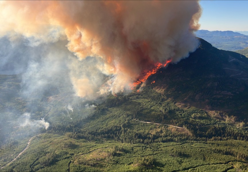
With evacuation orders already in place in British Columbia’s northeast and the uppermost sections of Canada’s prairies, the wildfire season hit Vancouver Island June 8 with a growing incident on the side of Nahmint Mountain.
Deep in Nuu-chah-nulth territory south of Sproat Lake, the Nahmint fire was first spotted during a hot Sunday when the temperature rose to 32 Celsius. Over the following day the fire grew to over 23 hectares, sending from the mountain a cloud of smoke that’s visible from Sproat Lake.
The BC Wildfire Service has responded with two initial attack crews of three to four personnel each, plus a 20-member unit crew also on scene. On June 9 three helicopters were being deployed to control the blaze and one piece of heavy equipment. The wildfire is believed to be human-caused.
As of the second week of June, this was the only forest fire active on Vancouver Island, but elsewhere in B.C. a wave of out-of-control incidents have led to highway closures and evacuation orders. All of the province’s wildfires of note lie in the northeast corner: the 61,050-hectare Pocket Knife fire, the nearly 20,000 hectares burning by Summit Lake and the over 21,000-hectare Kiskatinaw River blaze that has spread across the Alberta border.
Over 80 wildfires are active in B.C., with an estimated 70 per cent believed to be caused by human activity.
Neil McLoughlin is the superintendent of the BC Wildfire Service’s Predictive Services Unit. During a press conference held by the province on June 9 he noted that not all of these ignitions are intentional.
“That doesn’t mean there were necessarily people out there deliberately setting fires,” explained McLoughlin. “There’s a lot of different mechanisms for how a human-caused fire can start - whether that be a vehicle, heavy equipment, a rail line, a tree on a power line. All of those things qualify as a human-caused wildfire.”
While the number of human-caused incidents usually stay consistent over the fire season, McLoughlin expects lightning starts to increase over the summer.
B.C.’s northeast has an “extreme” fire danger rating, but most of Vancouver Island sits at “moderate” with the southern quarter south of Nitinaht lake rated “high”.
June rain will play a critical role in determining if this risk increases explained McLoughlin, who expects “warmer than normal temperatures” this month.
“June rain can really set the tone for the remainder of the fire season,” he said. “Areas that may experience healthy amounts of the precipitation in the weeks to come here, that just really helps to recover fuel moisture and lessen the fire danger as we head into the summer months.”
The amount of snow still waiting to melt from the mountains will also affect fire danger and drought this summer. As of early June Vancouver Island has 39 per cent of its normal snowpack, according to a recent bulletin from the province’s River Forecast Centre.
During the June 9 press conference David Campbell, the head hydrologist at the River Forecast Centre, expected an “accelerated melt” of this snow after a particularly hot weekend.
“About two thirds of the snow that we started with this year have now melted, while in a normal year we would have about half,” he said.
It was two years ago that western Vancouver Island communities became severely hindered when a wildfire broke out on the bluffs overlooking Cameron Lake. Debris fell onto Highway 4, cutting off road access for weeks – except a detour through logging roads that was deemed for essential travel only. The 2023 Cameron Bluffs wildfire eventually encompassed 229 hectares, costing the region an estimated $61 million in economic activity, according to a report from the region’s chambers of commerce.
It remains to be seen how difficult this fire season will be for western Vancouver Island residents, and while the snowpack is slightly lower at this time of the year than in 2023, some encouraging signs are evident in drought levels. Vancouver Island still sits with a Level 1 drought rating, according to the province - lower than it was two years ago. Meanwhile in B.C.’s high-risk northeast drought has reached levels of 3 and 4.
This summer the province is hoping improved camera systems will be able to detect wildfires faster.
“We’ve been making drastic changes to make sure that we can best tackle the wildfires that occur in our province,” said Minister of Forests Ravi Parmar. “Our wildfire aviation contracts are in place, and with the training and use of night vision technology, will help our crews work overnight and enhanced respiratory gear will help keep them safe.”
Wildfires have already burned for weeks through northern Saskatchewan, Manitoba and Ontario, leading the B.C. Wildfire Service to send help. Just over 100 of B.C.’s crew members have been fighting fires in these other provinces, amounting to approximately 10 per cent of the province’s suppression resources.
“We will continue to be there for them when conditions in B.C. allow,” said Parmar. “We expect the majority of our people and resources will be back in B.C. in the next week.”


