The Nov. 4 rainstorm that muddied water reservoirs in Ahousaht and Tofino also took a heavy toll on Hesquiaht Lake, 51 kilometres northwest of Tofino.
Several slides down the 750-metre-high Mt. Seghers, logged about 40 years ago, dumped large amounts of mud and woody debris into Hesquiaht Lake.
Stephen Charleson and his wife live in a remote area of Hesquiaht territory called Ayyisaqh, on the east side of Hesquiaht Harbour, accessible by boat in good weather.
Their rustic off-the-grid home is located two kilometres from an old logging road called Stewardson Main Line. The 14-kilometre road connects them to the sheltered Stewardson Inlet near Hot Springs Cove where they keep their boat tied up.
The road and boat are their only access to Tofino, 52 kilometres away.
“We leave our boat tied up at Stewardson from October to the end of April. We drive that road seven months of the year when the weather is bad,” said Charleson.
The couple leave home once or twice a month to take care of shopping, banking and to check their mail.
“We will watch the weather forecasts…quick trips,” said Charleson.
On Nov. 4 Charleson found the bridge over Hesquiaht Point Creek (Ihata) washed out, stranding him and his wife at Boat Basin.
“I drove to the washed out road at the bridge and saw the bridge is still there,” he wrote. “Looking further down towards the beach I noticed what looked like a huge slide on the opposite side of the creek. I walked down and was shocked to see the extent of the damage. The road, 150 meters from the bridge, fell into the creek and all the trees, bushes, rocks, stones, mud, etc. was washed down to the beach or into the ocean.”
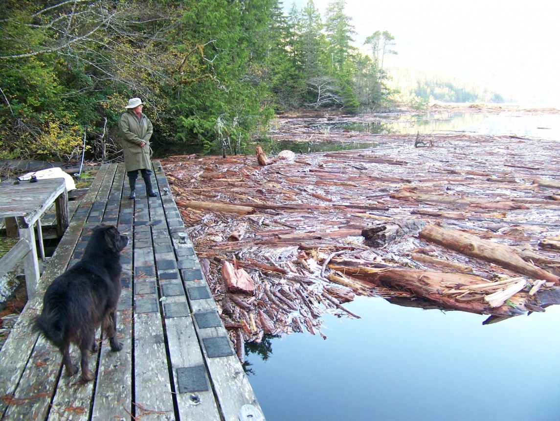
Upon further inspection of the area he discovered Hesquiaht Lake filled with woody debris as a result of seven or more landslides down Mt. Seghers. The Charlesons made several trips to the lake over the ensuing days documenting the damage.
On day nine he shared an image of Hesquiaht Lake filled from edge to edge with logs and woody debris. He noted that dog salmon (chum) are still visible in the lake.
Concerned that the debris will dam Hesquiaht Lake with a log jam, Charleson has been reaching out for help and answers.
On Nov. 18 he said, “Enough pictures and observation have been provided for everyone in charge to become concerned and come up to assess the situation for themselves. So far the only people we know of who have seen the slides into the lake have been the NTC fishery staff.”
Charleson noted that he saw and spoke to people that arrived at Hesquiaht Lake by helicopter Nov. 20. He determined that one person was a provincial Natural Resources officer and the other was working on behalf of MaMook Natural Resources.
A spokesperson with the Ministry of Lands, Natural Resource Operations and Rural Development told Ha-Shilth-Sa in an email that an investigation is taking place by a forester, a biologist and an engineering firm to determine the extent of the damage both within and outside the TFL area.
“Landslides occurred within a Tree Farm License (TFL) held by MaMook Natural Resources, and outside the TFL area, which is Crown land,” wrote the spokesperson.
Mt. Seghers, where the landslides occurred, was logged about 40 years ago - but not by the current tenure holders, Ma-Mook Natural Resources, which is owned by five Nuu-chah-nulth nations: Ahousaht, Hesquiaht, Tla-o-qui-aht, Yucluthaht and Toquaht.
“As the tenure holder, MaMook Natural Resources is responsible for maintenance of the roads and bridges in the TFL area,” said the ministry spokesperson.
MaMook Forestry Manager Zoltan Schafer was in meetings with Hesquiaht First Nation Elected Chief Richard Lucas, updating him on the situation. He said he had a report from a fisheries biologist in hand.
When asked if repairs would be made to Stewardson Main road, Schafer’s response was the decision would be up to the MaMook Natural Resources board of directors.
The Ministry of Forests spokesperson said the investigation by natural resource officers determined there was no evidence to show that road maintenance or harvesting are a likely cause for the landslides in question.
“That said, the area is prone to slides,” wrote the spokesperson
On Nov. 22 Charleson checked Hesquiaht Lake and noted that the main debris field is back at the top end of Tsaya Creek. Rain a few days earlier had pushed the debris further down the creek.
“The tide was rushing into the lake. Some of the debris that was around the bridge area went back up into the lake this morning,” said Charleson. “I haven't gone back in this afternoon but we can see small bundles of debris floating by Ayyisaqh (his home) for the past hour. Some of the debris is making it to the ocean but there is still a potential for a log jam.”
The ministry says results from their investigation, which are ongoing, will help determine the appropriate steps for remediation. They say they have been in communication with the Hesquiaht First Nation since Nov. 9.


