Provincial officials are warning people to be vigilant of an aggressive streamflow if a blockage on Chilcotin River suddenly breaks, while hoping that nature will correct the massive landslide.
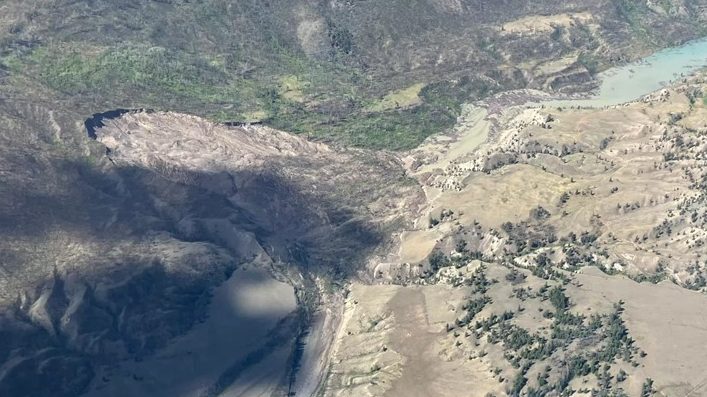
On the morning of Wednesday, July 31 a landslide occurred near Farwell Canyon in central B.C., blocking the passage of the Chilcotin, which feeds into the Fraser River. As of Friday, Aug. 2 the blockage measured 30 metres deep, stretching a kilometre and 60 metres in width, according to estimates from the province. With the river blocked, an 11-kilometre-long pool had grown behind the natural dam of sediment and debris.
An evacuation order was given for the immediate area, while the River Forecast Centre issued a high streamflow advisory for the Fraser River from Hope to where it meets the Chilcotin. On Friday evening the provincial agency expanded the evacuation order to the long portion of the river that stretches downstream from the landslide to the Fraser.
“The Chilcotin River Landslide poses a threat to human life,” stated the River Forecast Centre. “Ongoing flooding is occurring upstream of the landslide. Sudden, potential flooding and debris flow may occur downstream from the landslide.”
“Stay off of and away from both the Chilcotin and Fraser Rivers this long weekend,” warned Bowin Ma, B.C.’s minster of Emergency Management and Climate Readiness, during a press conference on Friday.
Ma urged those in the vicinity of the downstream Chilcotin and Hope to have a “grab-and-go bag” if any further evacuations are necessary.
“We are anticipating and preparing for the possibility of flooding in the area,” she said. “It is very dependent on how nature runs its course over the next 24 to 48 hours.”
The landslide location is being closely monitored, with time-lapse cameras and computer modelling to track how much the upstream pool is growing and if it could break through the dam-like barrier of sediment.
“The lake level might rise to the point where water begins to flow over the top of the dam and re-enter the riverbed below,” said Nathan Cullen, minister of Water, Land and Resource Stewardship, during the press conference. “It’s also possible that the water will seep through the dam and make its way downstream that way.”
Cullen noted that a major migration of salmon is anticipated to approach the landslide area in the next week or so. Besides being blocked, there are concerns of the fish being threatened by rising water temperatures in the Chilcotin River.
“We’re paying very close attention to not only stream flow, but also temperatures,” noted Cullen. “Salmon, of course, have terminal temperatures that they cannot survive beyond and will not spawn.”
It was over five years ago that another landslide blocked a portion of the Fraser River system, considered British Columbia’s most important pathway for salmon. In early 2019 over 85,000 cubic metres of rock fell down a cliff into the Fraser north of Lillooet. The Big Bar Slide forced years of response efforts that included physically transporting salmon around the rockslide, eventually leading to the construction of a permanent fish pathway at Big Bar – at a cost of $176 million.
But the Chilcotin landslide is different, explained Connie Chapman of B.C.’s Water Management Branch.
“The Big Bar slide and this slide are composed of very different materials,” she said. “The Big Bar slide was rock, and that is a much more stable slide, harder to move and is a longer-term natural infrastructure barrier that was placed within the river system.”
Chapman noted that other landslides occurred on the river in 2004 and 1964, which were corrected through natural processes.
“The current slide is composed of fine silt sands and clays,” she said. “It is more susceptible to erosion and movement than rock within the river.”
“There were reports of how salmon, which are an incredibly adaptable species specifically to these naturally occurring events, adapt to what comes forward,” said Cullen of the past landslides on the Chilcotin.
“The best-case scenario is that nature runs its course in a soft and gentle manner, and naturally clears the blockage and that this is done in a slow enough way that debris does not carry itself down the river and create more erosion along the way,” speculated Ma.
During the press conference officials were hesitant to identify the cause of the landslide, although Chapman confirmed that the location had been affected by wildfire.
Ma remarked that a combination of human-caused and environmental factors can lead to such an event.
“When you have historically poor forest management practices that result in clearcutting in certain areas, or an excess of fuel that help wildfires burn hotter in other areas, you end up with scarred landscape that is more susceptible to debris flows and landslides,” she said. “And then you exacerbate that with drought, you end up with scenarios when you can have drought at the same time as flooding in the province.”
Updated information on immediate hazards from the landslide is available at EmergencyInfoBC.ca.


