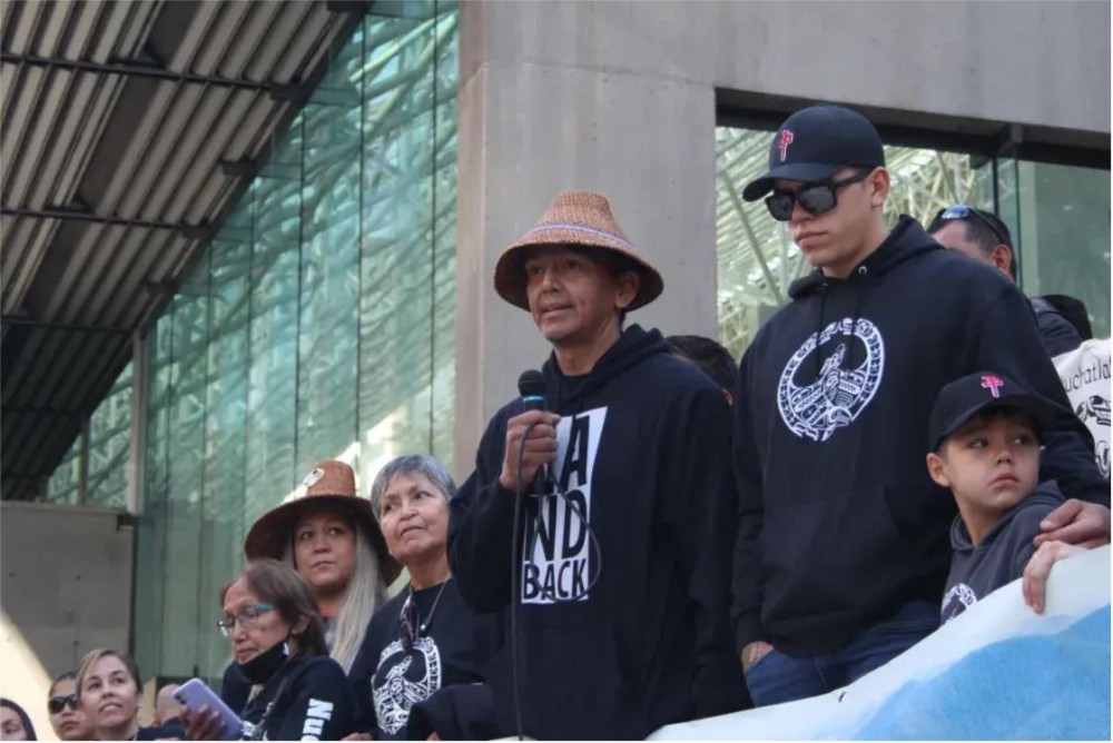
Nuchatlaht Tyee Ha’wilth Jordan Michael arrived at Vancouver Law Courts on Oct. 20, appealing the May 2023 decision of Justice Elliot Myers that determined that the Nuchatlaht are the rightful owners of some of their territory – but not all of it.
The Tyee Ha’wilth was accompanied by some of his people and his counsel, led by Jack Woodward. In addition, at least another dozen lawyers were present in person or by remote connection. The latter represented other parties, intervenors, that have an interest in the outcome of the appeal that took place for four days this week before three judges.
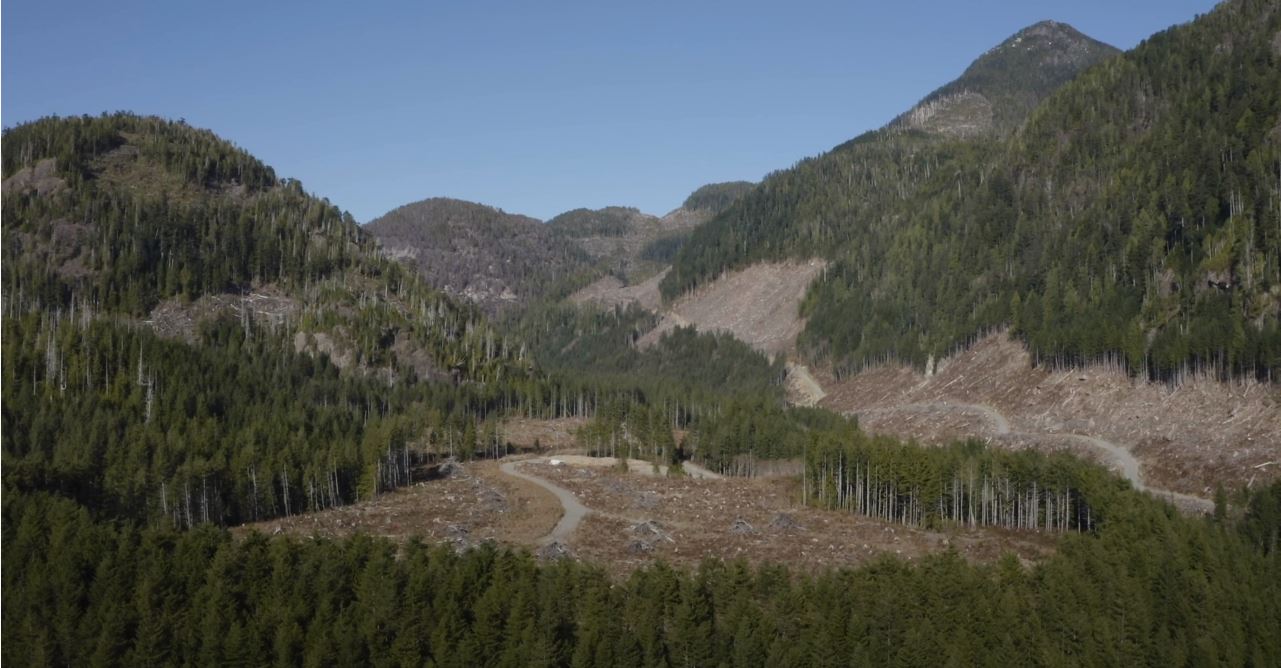
Nuchatlaht title trial tasked the nation to prove that they are the rightful owners of about 201 square kilometres of land. In his ruling, delivered in May 2023 with a further decision the following year on the extent of the title land, Justice Elliott Myers found that the Nuchatlaht had proven their case, but only in part.
In his interpretation of the evidence presented, Justice Myers found that the Nuchatlaht did not prove that they actively utilized their territory above the 100 metre line from sea level. Instead of the 201 square kilometres Nuchatlaht were expecting, they were recognized to have 11.33.
“With respect to the interior, there is almost no evidence of use by the Nuchatlaht,” wrote Myers, who was unconvinced that the nation’s ancestors left evidence of occupation above an elevation of 100 metres. “Confining the boundary to the 100-metre contour reflects the distinction between the coastal and interior areas.”
The appeal required the Nuchatlaht’s legal team is to show that the trial judge made an error of law.
On the opening day of proceedings Woodward started his presentation talking about 1778, the year Captain James Cook landed at the home of the Mowachaht in Yuquot. Woodward went on to say that it was at that time that the Nootka name was applied to the Mowachaht people and, eventually, to all their Nuu-chah-nulth relatives.
On his third official worldwide scientific journey in April 1778, Cook recorded in his writings that “no one had a higher idea of exclusive property” than the Nuu-chah-nulth. Woodward noted that there are several historic records that speak to this.
“The Nuchatlaht were not just hunters, fishers and foragers. They were also foresters,” said the lawyer, who argued that the Nuchatlaht relied heavily on forest resources for their everyday needs.
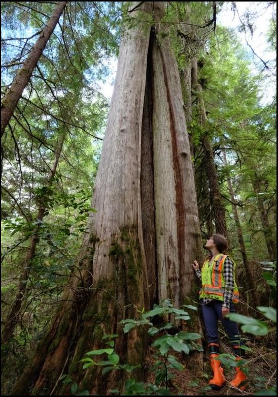
They needed forest materials that made them successful mariners and whale hunters, including 400-plus year-old cedar trees used to make large canoes, house posts and totem poles.
‘Postage stamp approach’ vs. territorial scope
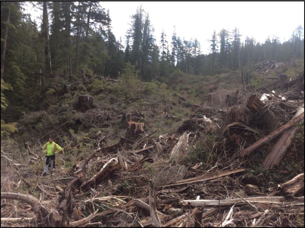
Nuchatlaht’s expert witness archaeologist, Jacob Earnshaw, has identified 8,386 culturally modified trees (CMTs) in Nuchatlaht territory - even though a large percentage of this area has been logged, thus erasing further CMT evidence.
The term culturally modified trees was first used in Canadian courts at the time of the Meares Island case in 1984. These are trees, stumps and logs that show evidence of being used or harvested for cultural purposes.
Woodward argued that the Nuchatlaht were wrongly confined by Justice Myers to small, specific parcels of land as opposed to territorial ownership.
“They’ve revived the postage stamp approach, which was rejected by the courts in the Tsilhqot’in case,” said Woodward.
He went on to say they would show that lands above a 100-metre elevation were wrongfully excluded from the Nuchatlaht claim by the judge and that Aboriginal perspective was not considered.
Woodword took the court through about two dozen maps illustrating Nuchatlaht territories from several different sources.
He noted that a map from anthropologist Philip Drucker, which is one of the earliest non-Nuchatlaht territorial maps, showed boundary lines that traced the mountain tops around the inland territories of a nation. The mountain top marks the highest point of a watershed and is often used as a marker to establish territorial boundaries.
Woodward said there is proof that the Nuchatlaht and other Nuu-chah-nulth nations made and utilized overland trails, like the Kyuquot Sound Trail, Nootka Trail and the Muchalaht Trail that led to the head of Alberni Inlet. These trails are identified in Drucker’s notes and are above the 100m contour line above sea level.
“You have the map made in 1771 showing the appellant claim of territory,” said Woodward. “You have both a European account and Aboriginal evidence showing claim of ownership. That is proof.”
But, he said, there is more evidence.
Heavy reliance on forest resources
Drucker’s notes show Nuu-chah-nulth industrial culture and a heavy reliance on coniferous trees. Felix Michael, who was great grandfather to the present day Nuchatlaht Chief Jordan Michael, was the tyee at the time Drucker was making his notes and was the principal Nuchatlaht informant for Drucker’s book on northern Nuu-chah-nulth tribes.
“I think the judge was unnecessarily dismissive of these maps,” said Woodward.
He offered up to the court maps from different sources made over time, mostly by Europeans. There was one made by Mowachaht Tyee Ha’wilth Maquinna and 11 others that Woodward said mostly come from peer review publications.
“The judge should not dismiss these maps as Drucker clones,” he said.
On the issue of CMTs, Woodward said the trial judge refused to acknowledge evidence that dates past 1846.
“It’s a science,” said Woodward. “You can determine when trees have been modified and the judge would not consider this.”
Woodward agreed with the trial judge that the Nuchatlaht occupied lands near the shore but stressed that, to survive, they needed inland resources as well.
Presenting maps by the BC Heritage Conservation and archeologists, Woodward demonstrated that Nuchatlaht forest harvesting activities went much further inland than 100 metres above sea level. Large red and yellow cedars were left to grow over 400 years to gain the straight, clear grain needed to make canoes, house posts and totem poles. They would have been left alone and would not show much in terms of forestry activity, argued Woodward.
Other cedar trees were reserved for bark or plank harvesting, leaving the tree alive to be harvested again in the future. These trees were not suitable for canoe making.
Woodward said he believed the judge made an error when he excluded Nuchatlaht CMT areas identified in the province’s own map.
According to Woodward, the court accepted maps submitted by the province that identified sites and not territories. That’s where the trial court erred, he stated.
“The province drew boundary at the 100-metre level with some exceptions,” said Woodward. He called the boundary line established by the trial judge arbitrary, as “there is no basis in Nuchatlaht culture” for this lineation based on elevation.
“We do not rely on habitation continuity in this case – instead, it is exclusive control of the lands,” Woodward commented of Myers ruling, “he is wrong because he misconstrued what it is.”
And if the Tsilhqot’in Aboriginal title is the test to prove other cases, Woodward said coastal First Nations not only meet that test, but they exceed it.
“The Nuchatlaht had intensive forestry activity and that is proven,” said Woodward.
Intervenors in the case includes Tseshaht, Ahousaht, Mowachaht/Muchalaht, Ehattesaht, Cowichan Tribes, Chemainus, Halalt, Tsawout, Dzawada’cnuxw, and Shishalh.